Lower York Gulch was closed twice in a five month period back in 2003: Mid-March: Avalanche during the blizzard, and Late Aug: Sinkhole due to mine collapse. The most common expected cause (fire) was not involved in either instance.
You Gotta Be Prepared!
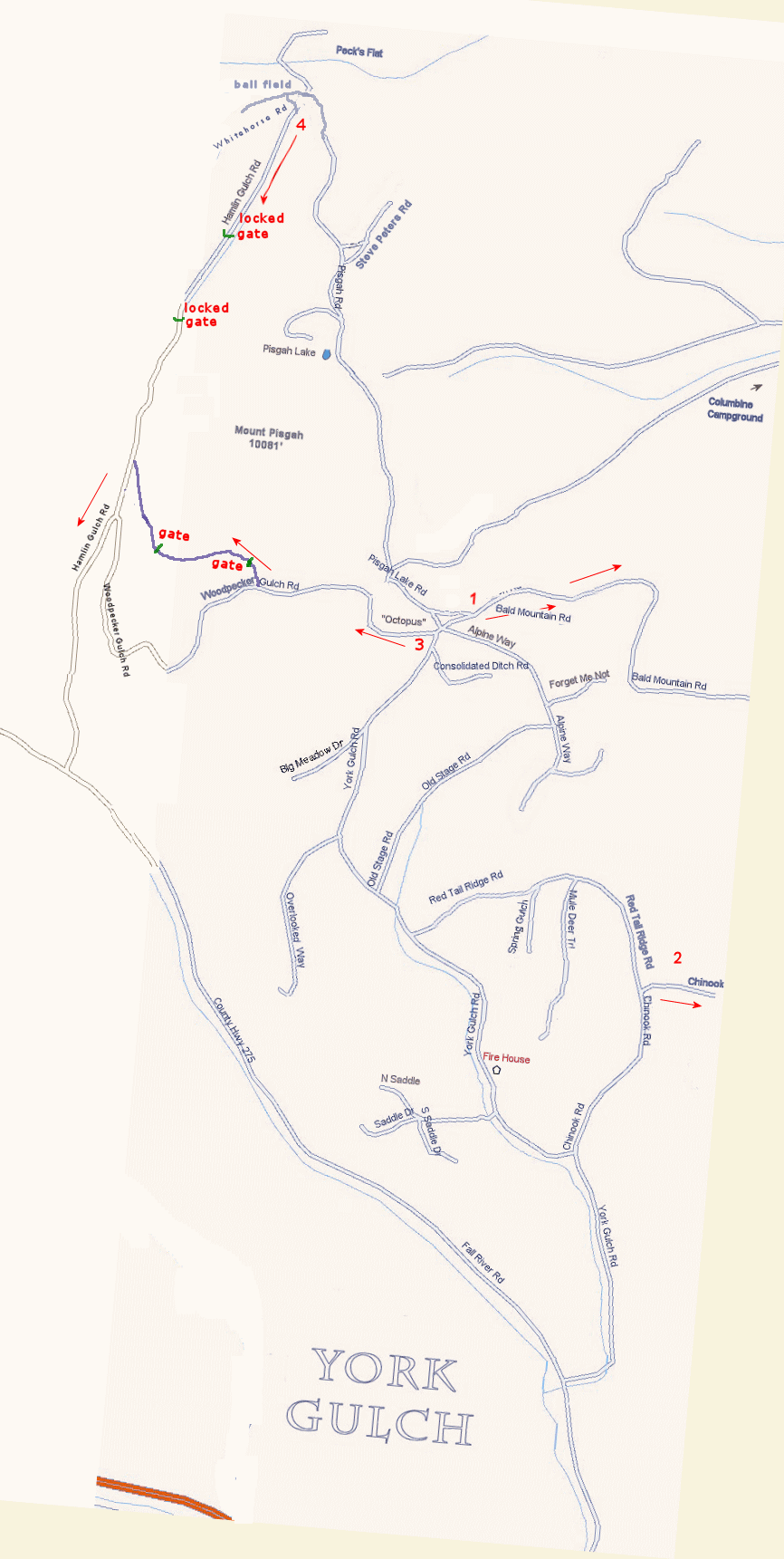
All this points to a need on the part of every one of us to have AT LEAST one alternate route out of the Gulch. Unless you live beyond Mt. Pisgah, where Hanlin Gulch Rd is your best option, there are three primary exits other than YG itself. Each is designated by a red arrow on the map below.
They are numbered, and once our plan is approved, and filed with the Clear Creek County Office of Emergency Management, we will mark each exit route with a numbered sign, and reverse 911 calls will suggest the best exit route based on the location of the emergency.
- 1. Bald Mtn. Road
- Go to the Octopus. Take first right. Stay on main road about 10 miles to top of Central City. Go into Central City and take 119 S to US 6. Or the new Central City Parkway is also an option.
- Advantages: Only 2WD alternative (always rough, and 2WD-passable only with minimal snow).
- Disadvantages: Longest route -- unless you want to spend the emergency gambling.
- 2. Chinook.
- Take either Lower Chinook or Red Tail Ridge to just below Dave Gallaher's house. Go up Upper Chinook to Gilpin County line (Odd Fellows cemetery #2 on your right) and on to Oh My God Rd. Right takes you to Idaho Springs, left to Central & Blackhawk. From there, new Central City Parkway is also an option.
- Advantages: Fastest route to good road; generally fastest to Idaho Springs.
- Disadvantages: Short portion (1/2 mile) requires both high clearance and GOOD tires. (No problem for a sturdy 4WD pickup.) An FYI Heather says her Subaru can make it all the way up Chinook.
- 3. Woodpecker Gulch.
- Upper Woodpecker Gulch Rd is well maintained and the best alternative if the eastern routes are blocked. Can be negotiated with a 2 wheel drive car, but high clearance or very careful driving is necessary. Drive to the Octopus, and turn west. Go about 1/4 mile. You will come to a fork in the road. The right hand road is gated. This is the road you will want to take. (Lower Woodpecker is a favorite with the ATVers, so it is in terrible shape.)The gate on upper Woodpecker is not locked, so go through the gate and close it behind you. The second gate is also unlocked. Please close that gate behind you as well. When you come to Hamlin Gulch Rd, turn left (downhill) and drive down to Fall River Rd. You will be about a mile above the York Gulch Rd exit.
- Advantages: Best way to get to Fall River Rd, and a western alternative if preferred eastern routes are not available.
- Disadvantages: Steep and rocky in places.
- 4. Hamlin Gulch.
- The northern escape route, for people on Pisgah Rd and points north and east, is Hamlin Gulch Road. In the event that York Gulch is blocked above the Octopus, this is the fastest way out. Drive up Pisgah Rd. past the "ballfield", turn on left Whitehorse Rd, and shortly after that left again on Hamlin to Fall River Road. This road is VERY steep. Use low or, if you have it, compound low. NOTE: There are two locked gates across this road. Since this is the safest of the north emergency exits, the county and USFS have been notified. This road is in rough shape in places, and could best be negotiated by a heavy-duty high clearance vehicle.
- We have asked the gate owners to either leave the gates unlocked, or put a combination lock on the gates and give the code to the sheriff. Until the gate issue is resolved, the sheriff has suggested ramming the gate, or shooting the lock.
- Advantages: Fastest route to I-70 for folks in the northern part of the Gulch, especially if other routes are blocked.
- Disadvantages: Very steep 4WD with several danger spots. Two locked gates. Consider this route a last resort.
The advantages and disadvantages are listed on the assumption that you will have a choice of exits (as in the case with the sinkhole). If your choice of exit is dictated by circumstances (as in the direction of a fire), you might still have choice of vehicle to take. Please use the route suggested by the Reverse 911 call.
As you can see from the map, the Alpine-to-Old Stage loop can circumvent a blockage in the top part of YG; and Red Tail-to-Chinook can get around blockage in the middle portion.
Emergency Routes in & out of York Gulch